UXO or Unexploded Ordnance refers to munitions, unexploded bombs, mines, torpedoes and bullets that have been used but which have failed to detonate. They are scattered near the coasts and in international waters, deposited on the seafloor surface or buried beneath it.
Nobody knows how many unexploded bombs remain and where they could be, since many of them have been inaccurately recorded or not have been recorded at all, but it is certain that considerable quantities of war material have been dumped into the sea around the world.
In this article we focus on certain aspects of marine UXO detection survey in shallow water.
Discarded military materials cause injury to human body and contamination of the marine ecosystem and benthic habitats, because of spontaneous explosion or contact with toxic chemicals and leakage of dangerous substances due to the corrosion of the munition casing.
Most UXOs belong to old and new conflicts, other sources are represented by military shooting and training ranges.
UXO devices are a danger to the fishing, energy industries and other sectors, including tourism and maritime activities.
To counter the threats of UXO, the Renewable Energy and Oil&Gas offshore companies have considered the use of state-of-the-art equipment, qualified and experienced consultants to assess and manage the UXO risk during construction projects, since such threats may block the project sites or pose a direct threat to safety.
Professionals involved have knowledge in geophysical survey, data processing, hydrographic and positioning skills.
For survey tasks, the market offers a wide range of detection solutions, efficient and flexible tools capable of recording information and data, useful to detecting bombs, ammunition and hazardous waste in underwater environment.
Underwater data is collected from vessels and small boats, from unmanned surface and underwater vehicles, through a range of detection equipment such as: acoustic systems, magnetometers sensors, gravity meters, etc.

In the shallow water, seabed surveys for UXO detection are performed using shallow draft boat or USV vehicle. These vehicles represent a cheaper solution than manned vessels or other unmanned underwater vehicles.
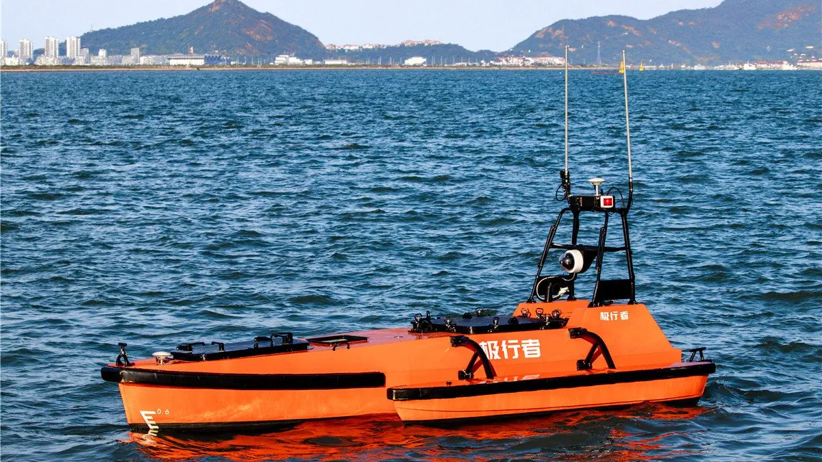
The M80 USV designed by the OceanAlpha company is able to carry up to 150kg of hydrographic & geophysical instruments to conduct multi-purposed hydrographic surveys on shallow water and deep sea.
In the case of a nearshore cable corridor area, the M80 USV or AVS vehicle can be used in order to locate the UXO threat or cable tracking and find an alternative route. It can be equipped with combined equipment and tools, such as Side Scan Sonar, Gradiometer, Magnetometer, Sub Bottom Profiler, Global Navigation Satellite System (GNSS) and Ultra Short Baseline, including the Inertial Navigation System, MultiBeam Echo Sounder.
To mitigate the risks, in some cases, projects could be modified during construction, by redirecting conductors or by moving subsea structures. This could also occur for the displacement of ordinance due to tides and other conditions including causes of seabed mobility. Then an UXO device could be moved over time due to seabed conformation, coastal morphology, currents and waves, fishing activities. Furthermore, the environmental conditions can bury any bomb, even of large sizes, within a few years.
The UXO do not represent a real problem for existing facilities, but they must be taken into account before realize a new subsea structure.
UXO is an explosive device designed to destroy or damage, therefore a geophysical survey for UXO risk mitigation is necessary in order to evaluate of the potential hazard and risk.
When security and safety conditions permit it, uncovered ordnance are transported safely to a blasting area, where they can be destroyed. In other cases the explosives can be detonated in place.
If these two options are not feasible, the bombs remain in place; in this case an authorization is required to verify and ensure the safety of the facilities.
Read more in the Digital JP Mag – JPmag – October 2021
Paolo Mazzone
SubEng – HSE Adviser
Side Scan Sonar – Used to identify objects and obtain an image of a large area of the seabed.
Used for buried objects identification and their locationing in a three-dimensional space. It is sensitive to gravity variations, due to density difference of objects under seabed floor.
Magnetic sensor, used at an altitude (distance from the bottom) of 2-5 meters for the detection of iron-based objects.
Global Navigation Satellite System – Used to accurately determine the location of an object, a vehicle, a geographical point.
Ultra-Short BaseLine positioning system – Acoustic positioning system use to determine the relative position of and object (ROV, AUV, etc) or diver from the supply vessel. It includes a tranceiver mounted under ship hull, a transponder on the object and a computer makes data available (distance and position).
Inertial navigation system – Set of devices that provide information on the motion of the vehicle (position, speed, inclination, acceleration, etc.). Once the initial speed and position data have been acquired from an external source, the system works independently without the need for further external inputs.
Sub Bottom Profiler – type of sonar utilised to identify objects and the various types of sediments under the seafloor.
MultiBeam EchoSounder – sonar system that emits directional acoustic beams in a fan shape; it is used to map and for bathymetric surveys of the seabed.
Images
Cover: 2013_05_09_Demolition_P byTobin Jones, AMISOM Public Information.
Article: USV M80, Oceanalpha.

